
Jug Bay Citizen Science
Jug Bay Wetlands Sanctuary relies on citizen scientists and volunteers to monitor and collect data and information about the many different habitats and species we found in our park. Currently, we have nine active programs that study turtles, butterflies, birds, forests, and vernal pools. Learn more about these opportunities below and contact us if you would like to join any of these opportunities!
Box Turtle Home Range Study
The charismatic Eastern Box Turtle, Terrapene carolina carolina, has become a species of concern throughout much of it's range. Needing large tracts of intact forest to complete its life cycle, there are fewer and fewer places that can support healthy populations. Additionally, roadway fatalities and collection as pets continue to reduce the populations of this once widespread reptile.
The forests of Jug Bay have proved to be a refuge for the box turtle. Since 1995, volunteer citizen scientists have marked individual box turtles with a notched code along the edge of their shell. They have identified over 600 individuals within a 300-acre area of the Sanctuary. Volunteers and staff members record measurements on every box turtle found. From repeated sightings, we are mapping the home ranges of individual turtles.
Over the years we have greatly expanded the regional knowledge on the Eastern Box Turtle. In addition to our mark-recapture study we also conduct radio telemetry work on 2-4 individuals per year; tracking their movements weekly to better understand the answers to the following questions:
- What sorts of habitats do box turtles prefer?
- What stimulates them to move about and search for food?
- Where do they nest and where do they overwinter?
- How long do they live?
This is an exciting program and we always welcome new volunteers!
To learn more and sign up please contact Liana Vitali, our Stewardship and Citizen Science Coordinator, at rpvita23@aacounty.org or 410.222.7810.
Bluebird Nest Box Monitoring
Volunteering to check Eastern Bluebird boxes involves regularly monitoring and maintaining nest boxes to ensure these native birds have safe and suitable habitats. This important activity supports the conservation of Eastern Bluebirds, a species that has faced significant population declines due to habitat loss and competition from non-native species. Volunteers help to provide critical nesting sites, collect valuable data on bluebird populations submitted annually to Project NestWatch, and contribute to broader conservation efforts. This hands-on experience not only supports local biodiversity but also fosters a deeper connection with nature and promotes environmental stewardship within the community.
To learn more and sign up please contact Liana Vitali, our Stewardship and Citizen Science Coordinator, at rpvita23@aacounty.org or 410.222.7810.
Forest Studies
Forests are the predominant upland habitat found throughout the Sanctuary. As a result of natural succession from past human activities (i.e. logging, mining, and grazing), some Jug Bay areas are characterized as young forests while other areas are dominated by mature open forests. No matter the successional stage, Jug Bay forests provide a variety of nesting sites, food resources, and habitat for a wide diversity of animals.
The main threats to Jug Bay forest communities include climate change, invasive species, and pressure from human development and land use changes. Changing temperature and precipitation regimes and an increase in the concentration of atmospheric carbon dioxide (CO2) are some of the factors related to climate change that may be impacting forest dynamics. On the other hand, population growth and development, increases in impervious surface, the loss and alteration of natural habitat in the watershed, and increases in point source flows are also issues of concern regarding Jug Bay forests. Finally, invasive species of both plants (i.e. Japanese stiltgrass, garlic mustard, tree-of-heaven, oriental bittersweet and others) and animals (i.e. white tail deer and emerald ash borer) have become increasingly problematic because of their tendencies to proliferate quickly, displace native species, and alter natural habitat.
Currently, the Sanctuary with the support of volunteers has three active projects, whose main goal is to monitor and assess the status of our forests or to implement efforts to combat their threats. These projects include:
- A forest survey which is conducted every three years;
- The monitoring of deer exclosures to assess forest regeneration;
- An effort to control the emerald ash borer and its impact in the ash tree population
A more detailed description of these projects is presented below. Additionally, the Sanctuary is planning to initiate a new project in 2020 to evaluate the implementation of controlled fires as a management technique to promote forest regeneration and diversity.
Forest Survey
In the interest of documenting a forest status baseline, Sanctuary staff and a team of volunteers surveyed Jug Bay forests in 2005 at the Glendening Nature Preserve and Sanctuary Proper, and wrote a report about their findings, highlighting species composition and density. After 13 years of this initial baseline, S. Ramsay, a summer research intern, re-surveyed in 2018 a subset of plots at both properties and analyzed the data to determine any changes in species dominance, importance, density, diversity, and richness. Although, few statistically significant changes were found, some trends were detected which could have management implications. The Glendening forest showed a significant increase in density due in large part to increasing young American beech (Fagus grandifolia) trees. Simultaneously, a decline in oak species (Quercus spp.) density in both properties was observed.
The Sanctuary will continue efforts to monitor the state of its forests; therefore, we will conduct in 2021 (and every three years) a re-do of Ramsay' survey. When the time comes we would welcome interested volunteers to help with the surveys and data processing.
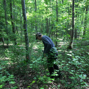
Seth Ramsey sampling a forest plot in 2018.
Deer Exclosures
Forests in Maryland are rapidly degrading. This was once caused primarily by land clearing and logging. Today forests are changing because old senescent trees are not being replaced by young trees. Tree seedlings that would grow to mature trees are being eaten by deer. Jug Bay Wetlands Sanctuary's woods have been suffering for many years from over-browsing by white-tailed deer. The seedlings and saplings of hardwood tree species such as oak, hickory and red maple are scarce. Wildflowers such as spring beauties, orchids, bloodroot and other species have also become rare. A browse line is evident in many areas of the Sanctuary.
Hundreds of acres of forest at Jug Bay are seriously damaged by deer. Dense deer populations are negatively impacting forest regeneration, natural succession, and biological diversity. Exotic invasive plants are also spreading in the Sanctuary as a result of the deer. No effort to reduce these impacts can succeed without managing the deer population within the park and other public lands. As a result, the Anne Arundel County Department of Recreation and Parks started in 2009 the implementation of managed hunts in some of its public parks, including Jug Bay.
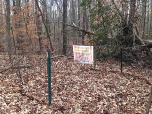
Deer exclosure at Jug Bay Wetlands Sanctuary
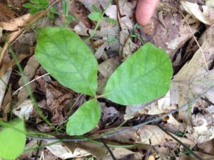
Oak seedling found within a deer exclosre.
In an effort to monitor the impact of deer management on the recovery of the forest understory, a total of ten exclosures of 10m2 were established in 2010 within the Sanctuary proper. Paired control sites (open plots) were established in 2014 for comparison purposes. These exclosures are sampled annually, and recently every two years, to record species presence, including numbers of seedlings and saplings.
The main goals of this monitoring project are to:
- Estimate the impact of deer management on the recovery of Jug Bay's forest understory.
- Inform the need of implementing additional forest restoration practices at Jug Bay.
- Promote the use of monitoring data for education and stewardship purposes.
To learn more about this opportunity and sign up please contact Liana Vitali, our Stewardship and Citizen Science Coordinator, at rpvita23@aacounty.org or 410.222.7810.
Emerald Ash Borer
The emerald ash borer (EAB) is an exotic insect pest originated from China and the Korean peninsula. EAB feeds on all species of ash (Fraxinus spp.), of which there are three species in Anne Arundel county: green, white, and pumpkin ash; all of them found at Jug Bay. Ash trees are commonly found along rivers, streams, and forested wetlands. EAB was first introduced to Maryland in 2002; since then its detrimental impact can be seen throughout the state, including Jug Bay.
If left untreated, EAB will ultimately infest and kill every ash tree in Jug Bay, the county, and Maryland, which will result in the loss of important tree cover not only in natural areas but in the urban setting as well. In addition to removal and chipping of infected trees, current science supports the use of insecticides (tree inoculation) for the treatment of low and no-infested trees as a conservation measure.
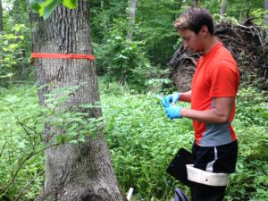
Jug Bay volunteer helping with ash tree inoculation.
Considering the imminent threat of EAB to Jug Bay's ash tree population, in 2014 the Sanctuary in collaboration with county forester Earl Reaves and staff from the Maryland DNR Forest Service decided to develop a plan to treat and try to protect a percentage of the healthiest ash trees at Jug Bay. As part of this effort, we mapped the main ash stands and conducted an assessment of the degree of tree infestation at the Glendening Preserve and Sanctuary proper; then used this information to develop an "ash treatment strategy" which was implemented in the spring of 2015, when approximately 85 trees were inoculated against EAB. A second treatment was done in 2017 and the final one will be completed in 2020. None of this work would have been possible without the support of volunteers. In this coming year, we welcome again our volunteers to support this effort by signing up for upcoming opportunities to help staff treat our ash trees.
By inoculating ash trees, we hope to conserve or at least extend the life (and value) of some of the most prominent ash trees (stands) present in Jug Bay, including specimens from the unique pumpkin ash species.
This project is currently retired. If you have any questions, please contact Liana Vitali, our Stewardship and Citizen Science Coordinator, at rpvita23@aacounty.org or 410.222.7810.
MAPS Songbird Population Study
MAPS - Monitoring Avian Productivity and Survivorship - is a continent-wide breeding season study started in 1989 by the Institute for Bird Populations in Point Reyes, California. About 400-450 stations operate nation-wide in any given year.
Sanctuary volunteers and staff initiated the Jug Bay monitoring program in 1990, making our bird banding station one of the oldest, continuously operating stations in the MAPS program. Every summer during the breeding season we operate 14 mist nets in our study plot in order to capture songbirds which we identify to species and then determine their age and sex. We make standard measurements of wing cord and weight for each bird, and place a USFWS band on the leg of each bird so we can identify it if we capture it again. We have banded over 2,500 birds to date.
Volunteers who help with this study learn how to operate mist nets, remove songbirds from the nets, and learn how to collect measurement data, and to identify and sex dozens of species of songbirds. Read about the project description and see these photographs of the Jug Bay MAPS operation to learn more about this volunteer opportunity.
Also, for more information about findings see below year end summaries for 2009, 2011, 2015, 2019 and a comprehensive 2016 MAPS report developed by our volunteers.
Volunteers Please Note: Banding occurs from late May through July. Participation for new volunteers is limited to observing, and we can only accept a very limited number of volunteers on each banding day.
Please send an email or call Liana Vitali, our Stewardship and Citizen Science Coordinator, at rpvita23@aacounty.org or 410.222.7810 to inquire about the schedule and to reserve a spot.
Fish Biodiversity Survey
Coming soon
To learn more about this opportunity and sign up please contact Liana Vitali, our Stewardship and Citizen Science Coordinator, at rpvita23@aacounty.org or 410.222.7810.
Stream Water Quality Monitoring
What do you see when you think of a beautiful, healthy stream? Your picture probably does not include trash, muddy water, or the smell of a latrine. But looks can sometimes be deceiving and just looking may not tell the whole picture. Sometimes we need a different perspective with very definite standards to really "see" the health and subsequent beauty of a stream. All living things are dependent on water, with fresh water streams providing a major habitat. What do we mean by "stream health"? Generally, we mean the ability of the stream to maintain life (both internally and externally). How do we quantify it? We still use as standards for comparison the historical reports of John Smith and the present day ability of Bernie Fowler to see his toes. However, technology provides us with ever increasing capabilities to measure and quantify the chemical and physical properties of our streams.
The Fall 2009 Marsh Notes reported on Andreas Moshogianis' summer research study to establish a physical baseline information for each of the Jug Bay stream watersheds. Following this and similar studies of the surrounding environs of the Sanctuary in 2009 (Marsh Notes Winter 2009/2010) a new focus was directed toward research and education about the land practices impacting the three watersheds at Jug Bay: Galloway Creek, Two Run Creek, and Pindell Branch. Since 1987 volunteers at Jug Bay have conducted a bi-monthly study of the Patuxent River and Two Run, measuring dissolved oxygen, water temperature, degrees of acidity, salinity, concentration of suspended particles, and the presence of chemical compounds (nitrates, phosphates, and ammonia) as well as the conductivity of the water. With this new emphasis in mind, the Volunteer Water Chemistry program regrouped in January 2010 to focus on these three streams. The new program included the same measurements as the earlier study, but emphasis was shifted from the River to two sites at each of the three contributing streams - Procedures Manual. The following parameters are currently being measured in the three streams.
- Dissolved oxygen (DO) - Dissolved oxygen is a measure of the amount of oxygen (O2) dissolved in the water. Oxygen is a necessary element to nearly every form of life. As dissolved oxygen levels in water drop below 5.0 milligrams per liter (mg/l), aquatic life is put under stress; the lower the concentration, the greater the stress. Oxygen levels that remain below 1-2 mg/l for a few hours can result in large fish kills.
- Acidity (pH) - The degree of acidity not only limits life within the stream, but also affects those animals who need streams for everything from drinking to breeding to a food source. A pH of 6.5 to 8.2 is optimal for most organisms.
- Turbidity, or cloudiness in water, is caused by suspended materials that scatter light passing through the water. The water chemistry program uses a turbidity tube which measures the depth at which one can see the water.
- Temperature -Temperature is one of different factors determining which species may or may not be present in a stream. Temperature affects the feeding, reproduction, and metabolism of aquatic animals. Thermal pollution (water running off hot roads and roofs) is a growing threat to species of cold-water streams. Temperature can also affect other parameters such as DO.
- Salinity - By definition, streams are not the place for salinity-loving creatures. Increased salinity due to erosion or runoff can change the basic nature of a freshwater stream.
- Chemical compounds - The concentrations of nitrates, phosphates, and ammonia determine the nutrient level of the stream.
- Nitrite/ Nitrate (NO2+3) is essential for plant growth, but the presence of excessive amounts in water supplies presents a major pollution problem. Nitrogen compounds may enter water from agricultural fertilizers, human sewage, industrial wastes, and livestock wastes. Nitrate level should be less than 0.5 mg/l.
- Phosphates (PO4) are naturally occurring. However, when found in excess they can accelerate the growth of algae and aquatic plants, causing eutrophication. Phosphate levels should be less than 0.05 mg/l.
- Ammonium (NH4) is found in fertilizers. It is also used in refrigeration. As a decomposition product of urea and protein, it is found in wastewater. Toxic levels of NH4 are pH- and temperature-dependent. Ammonium concentrations should be less than 0.05 mg/l.
- Conductivity is a measure of the ability of water to pass an electrical current. Conductivity in water is affected by the presence of inorganic dissolved solids such as chloride, nitrate, sulfate, and phosphate anions (ions that carry a negative charge) or sodium, magnesium, calcium, iron, and aluminum cations (ions that carry a positive charge). The basic conductivity measurement unit is the mho or siemens. Conductivity becomes critical only when studying other indicators of water quality, and is not in and of itself a major indicator.
Water Chemistry surveys are conducted by trained volunteers around the middle of each month throughout the year. To check our scheduled stream water quality sampling dates and to sign up please visit our calendar of events. Background knowledge in water chemistry is not necessary, and ongoing training is provided (volunteer program description).
Over time we hope the Stream Water Quality Monitoring Study will serve to document the impacts of development and global warming on our streams, the continued existence or loss of species, and most important, any changes to the environs that influence these three streams.
To learn more about this opportunity and sign up please contact Liana Vitali, our Stewardship and Citizen Science Coordinator, at rpvita23@aacounty.org or 410.222.7810.
Vernal Pool Monitoring
Vernal pools are temporary, shallow water habitats that are dry during the summer and fall. With winter snows and spring rains, they fill with water, providing breeding habitats for amphibians and invertebrates. At Jug Bay we have four obligate amphibian species: marbled salamander, spotted salamander, wood frog, and eastern spadefoot. Additionally two invertebrates, the fairy shrimp and fingernail clam have been found on site. Vernal pools are generally free of typical pond predators - fish and aquatic turtles do not remain in pools that dry up completely. However, the temporary nature of the pools creates a dilemma. If rains are delayed, or drought conditions occur, the pools will dry up prematurely, potentially leaving the frog and salamander larvae high and dry.
Jug Bay's Vernal Pool Monitoring Program aims to map the location of vernal pools, document how the pools change over time, and assess the status of their amphibian populations. Monitoring of vernal pools in the Sanctuary started around 2000, since then pools have disappeared and new ones have been and will be identified. Currently, a total of 11 vernal pools are monitored within the Sanctuary, ranging from 0.0001 ha to 2.5 ha in area.
The main objectives of this monitoring program include:
- Identify and map existing and new Jug Bay vernal pools. Monitoring their year-to-year permanence.
- Monitor the hydroperiod of the pools (the length of time and period of the year the pools hold water each year).
- Monitor the temporal use (through egg and larvae presence) of pools by obligate species, particularly wood frogs, spotted and marbled salamanders.
- Determine longterm changes of amphibian populations through egg mass counts.
- Determine the impact of climate change (e.g. water temperature changes) in vernal pools and their amphibian populations.
To address project objectives a volunteer-based monitoring methodology has been developed. This methodology is based on similar work done within the region and is practical enough to be conducted by volunteers with minimal training. The overall project will be coordinated by Sanctuary staff.
All Jug Bay vernal pools will be sampled every year during the breeding period from December 1 through June 1 or until the pools dry out. During this timeframe volunteers will visit the pools every week to collect data and document changes. If a pool (included within the list of pools to monitor) has not been used for breeding for three consecutive years, its monitoring may be discontinued. New formed pools will be added to the list and monitored for three years for signs of breeding activity, if none is shown during those three years its monitoring will then be discontinued.
Field work will involve the collection of data on four main subject areas: (1) hydroperiod; (2) habitat characteristics and pool area estimates; (3) water quality; and (4) amphibians. Each of these areas follows specific protocols and data will be collected by Jug Bay staff and/or volunteers.
To learn more about this opportunity and sign up please contact Liana Vitali, our Stewardship and Citizen Science Coordinator, at rpvita23@aacounty.org or 410.222.7810.
Winter Waterbird Survey
Jug Bay tidal freshwater wetlands are an important stop within the area for migrating birds in the spring and fall. Many stay for the winter as well. Over 60 species have been documented since the survey started in 1990. View this seasonal abundance table for an example of what birds to expect and when.
The Winter Waterbird Survey is run by volunteers and consists of a four stop point count conducted bi-weekly during the non-breeding season (November through April). The survey starts at the Sanctuary's observation deck and follows the railroad bed trail. The same 2-mile path is followed each time. The survey starts at 7:30 am and it lasts for about 2-3 hours. Actual individual counts are recorded, but when birds are found in larger flocks or they move too quickly, an estimation is used. All data is recorded and reported through e-bird and saved in a master spreadsheet kept at the Sanctuary. Overall, this survey tracks the diversity and abundance of geese, swans, ducks, shorebirds, raptors, and other birds that frequent the wetlands of the Jug Bay area. The first bird survey was on February 6, 1990 and it continues to date.
To learn more about this opportunity and sign up please contact Liana Vitali, our Stewardship and Citizen Science Coordinator, at rpvita23@aacounty.org or 410.222.7810.
Salamander Migration Monitoring
Coming soon.
To learn more about this opportunity and sign up please contact Liana Vitali, our Stewardship and Citizen Science Coordinator, at rpvita23@aacounty.org or 410.222.7810.