
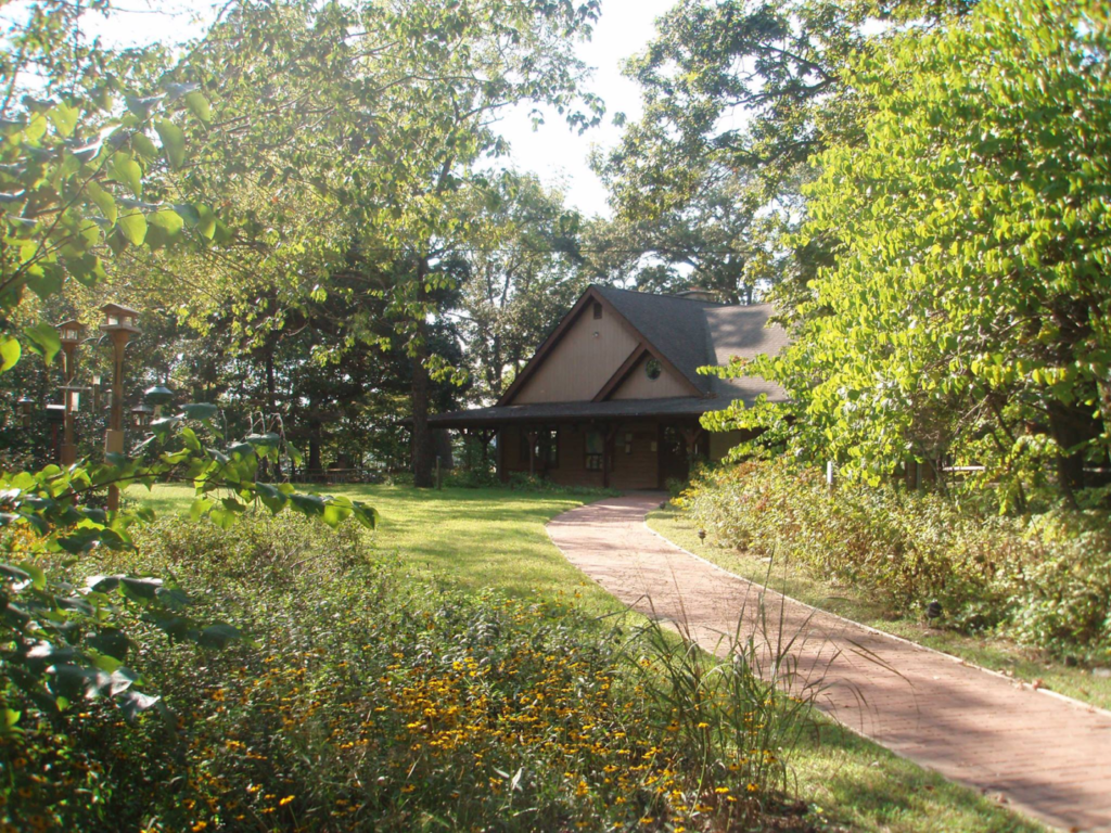
Walk the boardwalks along the marsh, watch the osprey dive for fish, enjoy the forest canopy. This quiet place in southern Anne Arundel County is just 40 miles south of Baltimore City, 22 miles east of Washington, DC, and 22 miles south of Annapolis.

Trail Maps
Jug Bay Wetlands Sanctuary Proper (all trails)
Jug Bay Wetlands Sanctuary Proper (yellow loop & Marsh Boardwalk zoom)
Glendening Nature Preserve, Patuxent Wetlands Park, and Nature Preserve at Waysons Corner
Try our Sanctuary Proper Audio/Visual Self-Guided tour of the Yellow Loop. It is a downloadable PDF document with text and pictures and/or an audio playlist. Formerly the QR code tour. Each stop is indicated by green dots on the trail map.
**NEW**Visiting Glendening Nature Preserve (GNP)? Try the new Pocket Naturalist self-led hike! Download and learn more here.

Paddle-In Campsites

There are 2 paddle-in only campsites available at Jug Bay Wetlands Sanctuary's Emory Waters Nature Preserve. We do not provide overnight parking at the Sanctuary. There is a port-a-potty available on site. No fires. No pets.

Field Trips and Private Group Programs
Jug Bay Wetlands Sanctuary is a natural and cultural treasure in Anne Arundel county creating unforgettable experiences for both students and visitors.
To request a field trip for your school group, please refer to our Education page for information on our Classrooms in the Field (CITF) program and how to apply.
To request a private land-based or canoe program for your group or organization, please fill out this form.
Host Your Next Event at Jug Bay!
Jug Bay Wetlands Sanctuary is an inspiring setting for nature-based programming. Home to 1,700 acres of woodlands, wetlands and meadows, and 15 miles of trails, our facility and grounds are ideal for nurturing connections with the natural world. There are several rental options available both at the Sanctuary Proper and the Glendening Nature Preserve.
To inquire about our rental locations or to make a reservation, please call Jug Bay Wetlands Sanctuary at 410-222-8006 or email jugbay@aacounty.org.
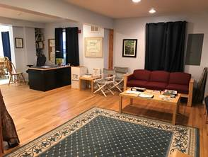
Located inside the Visitor Center at the Sanctuary Proper, this large, open, multi-purpose room - rented for professional activities only - is ideal for lectures, hands-on workshops, and professional retreats. The conference room is 37' x 18'.
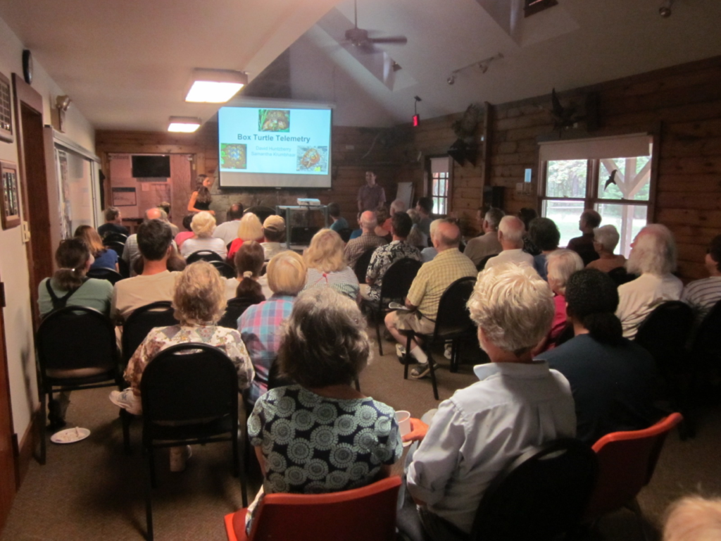
Visitor Capacity: 20 people seated with tables; 30 people seated in chairs alone.
Parking Capacity: Twenty vehicles in the main lot with additional parking space available in an overflow field.
Audio/Visual: Use of a computer, projector, and screen is included in the room rental rate. Speakers are not included. Wi-Fi is available. Users are welcome to bring their own hot spots if Internet access is required, but signal strength may be weak.
Restrooms: Separate men's and women's bathrooms with flushing toilets are available. Please note that bathrooms are shared with public visitors on days the Sanctuary is open to the public (Wednesday, Friday, Saturday, and Sunday*).
Food: Users can serve food and would have access to the kitchen containing a refrigerator, microwave, stove, and counter space.
Fees: $55 half day (up to four hours), $110 full day (between four and eight hours). If planning to use the grounds and not just the building, the $6 vehicle entrance fee will be required in addition to the rental fee.
*Sanctuary Proper is closed on Sundays from December through February.
Located at the Sanctuary Proper, this large, outdoor, covered structure has several uses with the following prioritization: (1) education programs; (2) public and community events; (3) private family activities. If private family use is of interest, please contact the Sanctuary via the information below to learn about additional guidelines for this type of use. The Pawpaw Pavilion is available for rentals on Wednesdays, Fridays, Saturdays, and Sundays*.
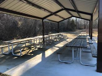
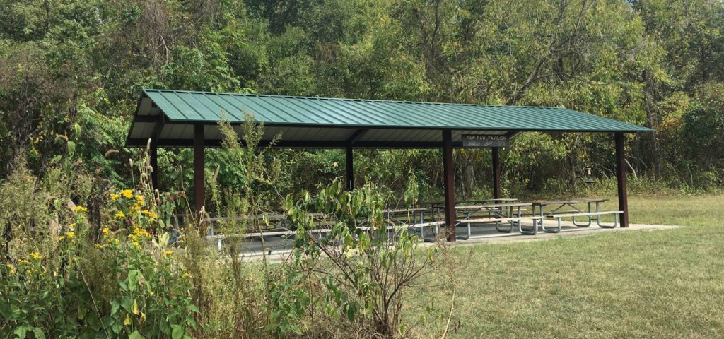
Capacity: 30 people seated at picnic tables.
Parking Capacity: Twenty vehicles in the main lot with additional parking space available in an overflow field.
Audio/Visual: No audio/visual amenities are included in this rental.
Restrooms: Restrooms are available a short walk away in the McCann Wetlands Center. Separate men's and women's bathrooms with flushing toilets are available. Please note that bathrooms are shared with public visitors on days the Sanctuary is open to the public (Wednesday, Friday, Saturday, and Sunday*).
Food: Users can serve food. No kitchen space is available in this rental, and no cooking is permitted.
Fees: $30 half day (up to four hours), $60 full day (between four and eight hours). All vehicles must also check in at the Visitor Center to pay the required $6 vehicle entrance fee.
*Sanctuary Proper is closed on Sundays from December through February.
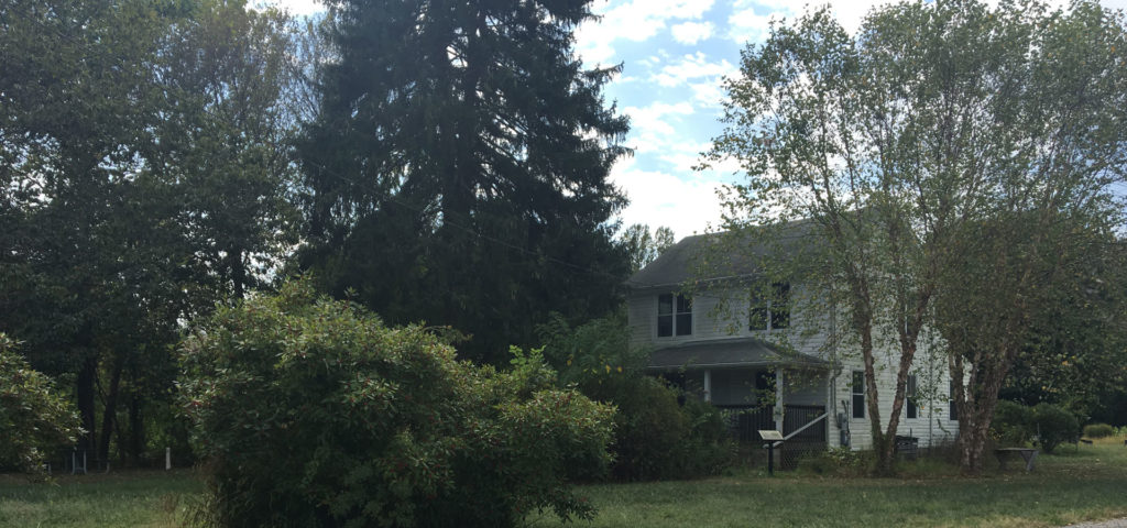
Located at the Glendening Nature Preserve and accessible from the entrance on Plummer Lane, this stand-alone house is ideal for smaller meetings and working sessions, or makes an ideal headquarters location for programs that lead participants on outdoor experiences. Rented for professional activities only.
Capacity: 15 people.
Parking Capacity: Limited to ten vehicles.
Audio/Visual: Wi-Fi is available at this location along with a projector screen. A computer, projector, and speakers are not included.
Restrooms: Two unisex bathrooms with flushing toilets are available. Bathrooms are shared with public visitors Monday through Saturday.
Food: Users can serve food and would have access to the use of the kitchen containing a refrigerator, microwave, and counter space.
Fee: $30 half day (up to four hours), $60 full day (between four and eight hours).
Directions
1361 Wrighton Road, Lothian, MD 20711
410-222-8006
From Annapolis
From West St. at Parole, take Route 2 south 18 miles. At the Lothian "circle" go 3/4 of the way around and stay on Route 2. Go past the fire station, schools and St. James Church (on left) until the next stoplight at Route 258; go right (west) on Rt. 258. Continue on Route 258 for 4.5 miles until this ends near the "Park and Ride" just after crossing over Route 4. At the stop sign, turn onto Wrighton Rd. and continue for 1.5 miles to Sanctuary entrance on LEFT. Follow the gravel drive about 1 mile to the parking area for the Wetlands Center.
From Baltimore at the Baltimore Beltway (Route 695)
From Route 695, take I-97 south. I-97 ends at Route 50. Take Route 50 West/301 South. 301 South will split from Route 50. Continue on Rt. 301 south to Route 4 at Upper Marlboro. Go east/south on Rt. 4 for 3 miles (1.5 miles after crossing over the Patuxent River) to the "Plummer Lane" exit on right. Follow Plummer Lane for 1/2 mile to Wrighton Road. Go right on Wrighton Rd. and continue for 1/2 mile to Sanctuary entrance on LEFT. Follow the gravel drive about 1 mile to the parking area for the Wetlands Center.
From Washington, DC
Take Pennsylvania Ave. east to Capital Beltway (Route 495). At the Beltway, Pennsylvania Ave. becomes Route 4; follow Route 4 east/south for about 10.5 miles to the "Plummer Lane" exit. (Plummer Lane is 3 miles east of Rt. 301 and 1.5 miles east of the Patuxent River). Exit right at Plummer Lane and go 1/2 mile to Wrighton Road. Go right on Wrighton Rd. and continue for 1/2 mile to Sanctuary entrance on LEFT. Follow the gravel drive about 1 mile to the parking area for the Wetlands Center.
From Calvert County
Take Route 4 north and exit at the "Bristol-Deale" exit (Route 258). At stop sign go left over Route 4, and continue to stop sign at Wrighton Road (near "Park and Ride"). At the stop sign, turn onto Wrighton Road and continue for 1.5 miles to Sanctuary entrance on LEFT. Follow the gravel drive about 1 mile to the parking area for the Wetlands Center.
5702 Plummer Lane, Lothian, MD 20711
From Annapolis
From West St. at Parole, take Route 2 south 18 miles. At the Lothian "circle" go 3/4 of the way around and stay on Route 2. Go past the fire station, schools and St. James Church (on left) until the next stoplight at Route 258; go right (west) on Rt. 258. Continue on Route 258 for 4.5 miles until this ends near the "Park and Ride" just after crossing over Route 4. At the stop sign, turn onto Wrighton Rd. and continue for 1 mile to a stop sign. Turn right onto Plummer Lane for ¾ of a mile to the entrance to the Glendening Nature Preserve on the left just before the intersection with Rte 4.
From Baltimore at the Baltimore Beltway (Route 695)
From Route 695, take I-97 south. I-97 ends at Route 50. Take Route 50 West/301 South. 301 South will split from Route 50. Continue on Rt. 301 south to Route 4 at Upper Marlboro. Go east/south on Rt. 4 for 3 miles (1.5 miles after crossing over the Patuxent River) to the "Plummer Lane" exit on right. Look for a sign almost immediately on your right for the Glendending Nature Preserve entrance.
From Washington, DC
Take Pennsylvania Ave. east to Capital Beltway (Route 495). At the Beltway, Pennsylvania Ave. becomes Route 4; follow Route 4 east/south for about 10.5 miles to the "Plummer Lane" exit. (Plummer Lane is 3 miles east of Rt. 301 and 1.5 miles east of the Patuxent River). Exit right at Plummer Lane. Look for a sign almost immediately on your right for the Glendending Nature Preserve entrance.
From Calvert County
Take Route 4 north and exit at the "Bristol-Deale" exit (Route 258). At stop sign go left over Route 4, and continue to stop sign at Wrighton Road (near "Park and Ride"). At the stop sign, turn onto Wrighton Road and continue for 1 mile to a stop sign. Turn right onto Plummer Lane for ¾ of a mile to the entrance to the Glendening Nature Preserve on the left just before the intersection with Rte 4.
To enter the Glendening Preserve via the Wrighton Road parking area, follow the directions above to Jug Bay Wetlands Sanctuary. The parking area is on the RIGHT, just before the Sanctuary driveway (which is on the left).
1426 Mt. Zion Marlboro Rd, Lothian, MD 20711
Patuxent Wetland Park is located at the edge of the Patuxent, off Marlboro Road (Route 408), three miles up river from the Sanctuary.
From Annapolis
From West St. at Parole, take Route 2 south 4 miles until the intersection with Central Ave (MD-214). Turn right and continue 5 miles. Then turn left on Patuxent River Road for a little over 2 miles. Finally turn right on Sands Rd and continue for almost 4 miles to Waysons Corner. A sign for Patuxent Wetlands Park will appear on your right just after the gas station and before the Rte 4 overpass.
From Baltimore at the Baltimore Beltway (Route 695)
From Route 695, take I-97 south. I-97 ends at Route 50. Take Route 50 West/301 South. 301 South will split from Route 50. Continue on Rt. 301 south until a right onto Queen Anne's Bridge Road. Continue for just over 2 miles until making a left onto Central Ave (MD-214). Follow Central Ave for 1 mile and make a right on Patuxent River Road. After two miles, turn right on Sands Rd and continue for almost 4 miles to Waysons Corner. A sign for Patuxent Wetlands Park will appear on your right just after the gas station and before the Rte 4 overpass.
From Washington, DC
Take Pennsylvania Ave. east to Capital Beltway (Route 495). At the Beltway, Pennsylvania Ave. becomes Route 4; follow Route 4 east/south for about 8 miles to the MD-408 exit on right. At the stop sign, make a left and cross the Rte 4 overpass. The entrance to Patuxent Wetlands Park is the first left after the bridge, before the gas station.
From Calvert County
Take Route 4 north and exit at 408 E towards Waysons Corner. Turn left onto Southern Maryland Blvd and continue for about 0.2 miles until the intersection with MD-408. Make a left Continue onto Southern Maryland Blvd for 0.3 miles. Turn right onto Sands Rd and drive just over 4 miles. Wootons Landing Wetlands Park will appear on your left. A sign for Patuxent Wetlands Park will appear on your right just after the gas station and before the Rte 4 overpass.
4550 Sands Road, Harwood, MD 20776
Wootons Landing is a 140-acre park along the edge of the Patuxent, off Sands Road, seven miles upstream from the Sanctuary.
From Annapolis
From West St. at Parole, take Route 2 south 4 miles until the intersection with Central Ave (MD-214). Turn right and continue 5 miles. Then turn left on Patuxent River Road for a little over 2 miles. Finally turn right on Sands Rd and continue for almost 3 miles. Wootons Landing Wetlands Park will appear on your right.
From Baltimore at the Baltimore Beltway (Route 695)
From Route 695, take I-97 south. I-97 ends at Route 50. Take Route 50 West/301 South. 301 South will split from Route 50. Continue on Rt. 301 south until a right onto Queen Anne's Bridge Road. Continue for just over 2 miles until making a left onto Central Ave (MD-214). Follow Central Ave for 1 mile and make a right on Patuxent River Road. After two miles, turn right on Sands Rd and continue for almost 3 miles. Wootons Landing Wetlands Park will appear on your right.
From Washington, DC
Take Pennsylvania Ave. east to Capital Beltway (Route 495). At the Beltway, Pennsylvania Ave. becomes Route 4; follow Route 4 east/south for about 8 miles to the MD-408 exit on right. At the stop sign, make a left and drive one mile to the intersection with Sands Rd. Make a left onto Sands Rd and drive just over 3 miles. Wootons Landing Wetlands Park will appear on your left.
From Calvert County
Take Route 4 north and exit at the "Southern Maryland Blvd" exit. Continue onto Southern Maryland Blvd for 0.3 miles. Turn right onto Sands Rd and drive just over 4 miles. Wootons Landing Wetlands Park will appear on your left.
PLEASE NOTE: There are no restroom facilities at Wootons Landing.
Drive to within 50 yards of the floating canoe dock and launch your boat. After off-loading your boat, please drive your car back to the parking lot next to Sands Road to ensure that the space near the launch is accessible for other paddlers.
Sands Road runs north/south along the river between Routes 408 (Mt. Zion Marlboro Road) and Harwood Road. Parking is on the west side of the road, across from the Maryland Manor mobile home community.
From Annapolis
From West St. at Parole, take Route 2 south 12 miles until the intersection with Sands Rd about a mile up from Waysons Corner. Make a left on Sands Rd. A parking lot entrance will appear on your right about one half mile down the road.
From Baltimore at the Baltimore Beltway (Route 695)
From Route 695, take I-97 south. I-97 ends at Route 50. Take Route 50 West/301 South. 301 South will split from Route 50. Continue on Rt. 301 south to Route 4 at Upper Marlboro. Go east/south on Rt. 4 for 2 miles (0.5 miles after crossing over the Patuxent River) to the MD-408 exit on right. At the stop sign, make a left and drive one mile to the intersection with Sands Rd. Make a right on Sands Rd. A parking lot entrance will appear on your right about one half mile down the road.
From Washington, DC
Take Pennsylvania Ave. east to Capital Beltway (Route 495). At the Beltway, Pennsylvania Ave. becomes Route 4; follow Route 4 east/south for about 8 miles to the MD-408 exit on right. At the stop sign, make a left and drive one mile to the intersection with Sands Rd. Make a right on Sands Rd. A parking lot entrance will appear on your right about one half mile down the road.
From Calvert County
Take Route 4 north and exit at the "Southern Maryland Blvd" exit. Continue onto Southern Maryland Blvd for 0.3 miles. Turn right onto Sands Rd. A parking lot entrance will appear on your left less than one half mile down the road.
PLEASE NOTE: There are no restroom facilities at the Nature Preserve at Waysons Corner.